
As part of our ongoing digitization mission at Civile, process automation is integrated directly into our DMO (Digitalization Manager Office). The DMO is not simply a working group; it is a multidisciplinary team made up of colleagues from all departments of the company dedicated to driving the standardization and improvement of processes and workflows. This development is a reflection of our vision: to combine standardization and innovation with production, and to make changes organically. The incorporation of tools such as PyQGIS into our workflows is a testament to our commitment to digitization and optimization in the field of civil engineering.
GIS Workflow Automation with PyQGIS
Resource optimization in any workflow is essential. At Civile we are aware that simple but repetitive tasks, even if they seem minor, consume valuable time. That time could be spent on more complex and in-depth tasks that require our attention and expertise. With this understanding, we have placed a strong emphasis on automating these processes to free up that crucial time.
PyQGIS: A powerful toolset
PyQGIS is not just a Python library for QGIS; it is a gateway to automating and extending the capabilities of QGIS. Being part of Python, PyQGIS offers the flexibility, transparency and collaboration that only open source solutions can provide. Working with these tools not only means having access to powerful and adaptable software, but also being part of a global community that shares, collaborates and constantly improves the software. With PyQGIS, we combine the power of a programming language like Python with the vast capabilities of QGIS, leveraging a robust and collaborative environment for geospatial data analysis and manipulation.
Process functionality
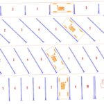
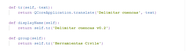
The process of identifying the catchment basins at specific points is an essential process in all the work of the Water Engineering Area. The correct operation of this process is fundamental for obtaining quality results and, therefore, requires special attention. It is a simple process, but with a high resource cost, which makes it an ideal process to automate. Through PyQGIS, we have developed a Python script integrated in QGIS processes that allows us, from a runoff layer and flow accumulation sub-basins, to delimit complex catchments for specific control points.
This processing tool is able to analyze the flow of water through the runoff layer provided to the control points by joining the associated sub-basins to form complete catchments. The process is able to identify areas of confluences of various flows and separate the input into independent basins to facilitate subsequent hydrological treatment.
Possible future developments
Looking ahead, one of the developments we are considering is obtaining the characteristic parameters of the calculated catchments. For this, we plan to integrate and make use of the QGIS Graphical Modeler, a powerful tool that we have already highlighted in previous publications.
If you are interested in collaborating or learning more about this project, don’t hesitate to get in touch!
Written by:
Agustin Hormigo
Civil Engineer
Water Engineering Area


